
Bucket Chain Diamond Dredgers: Matching Digging Depth to Alluvial Deposits
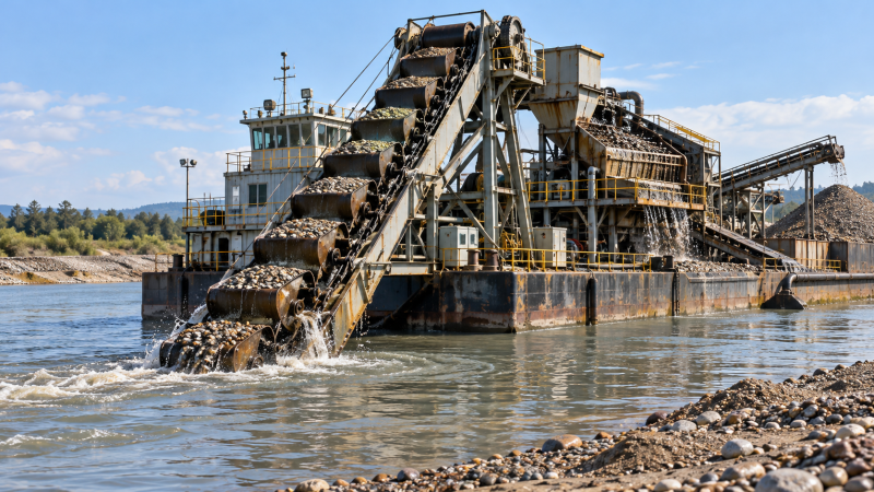
A dredger that can reach the bottom of an alluvial deposit may still be unable to mine it effectively. The decisive question is whether it can excavate the productive gravel, manage the material above it, and deliver a controllable feed to the recovery plant throughout the expected water-level range. Maximum digging depth is only one boundary of that operating envelope.
For technical evaluators, depth selection should begin with deposit geometry and a common elevation datum—not a catalogue specification. Bucket-ladder dredgers excavate through a circulating chain of buckets, so working depth is linked to ladder geometry and operating position. Excavation performance also depends on the material encountered and the way the dredger advances across the face. These relationships are described in established dredging references, including Dredging: A Handbook for Engineers.[1]
Define the target horizon before specifying depth
An alluvial investigation needs to distinguish the riverbed or pond floor, overburden, potentially economic gravel, and the underlying excavation boundary. Bathymetry identifies the submerged surface; it does not establish the thickness or continuity of buried diamond-bearing material. Geological sampling and appropriate subsurface investigation must provide that interpretation.
The equipment specification should translate the geological model into an excavation envelope. Record the elevations of the top and base of each relevant unit, the anticipated operating water levels, and areas where the deposit remains uncertain. The resulting schedule should distinguish three depths:
- Depth to first productive material: the excavation required before potentially valuable feed reaches the buckets.
- Depth to the planned mining floor: the depth required to recover the intended gravel interval.
- Maximum permitted excavation depth: the boundary established by the mine plan, engineering assessment, and applicable approvals.
These depths should not be treated as interchangeable. Designing around the average gravel elevation can leave deeper pockets inaccessible. Designing around the deepest isolated observation can commit the project to a larger machine without establishing that the additional material justifies the expense.
Consider a purely illustrative section: at the selected low operating water level, the bed lies four metres below the surface, three metres of overburden cover the target gravel, and the gravel is one metre thick. Reaching its base requires eight metres of excavation below that water surface. This is a geometry example, not a recommended dredger rating; it excludes site-specific allowances and does not establish excavation feasibility.
Repeat the calculation across the deposit rather than at one representative section. Where exploration spacing leaves uncertainty about the basal surface, show that uncertainty separately instead of concealing it inside a generous depth allowance.
Convert catalogue depth into a working envelope
A quoted maximum digging depth needs a defined reference condition. Ask whether it is measured from the operating waterline, a stated vessel datum, or another reference. Also establish the associated draft, ladder angle, bucket arrangement, and loading condition. Without these definitions, apparently comparable offers may describe different capabilities.
For a bucket chain diamond dredger, the relevant evaluation is the complete excavation-and-recovery arrangement: bucket ladder, chain drive, supporting hull, material transfer, screening, and mineral recovery. A gold/diamond equipment designation identifies an application category, but it does not establish that the proposed configuration suits a particular diamond deposit. Geological and processing requirements still need to be reconciled with the supplied arrangement.
As an initial geometric check, the vertical reach of a straight ladder depends on its effective length and angle below horizontal, together with the pivot elevation. However, that simplified relationship is not an acceptance calculation. The actual bucket path, lower tumbler geometry, hull trim, and mechanical clearances require the supplier’s arrangement drawings and operating limits. Bucket-ladder geometry and dredging arrangements are covered in reference [1].
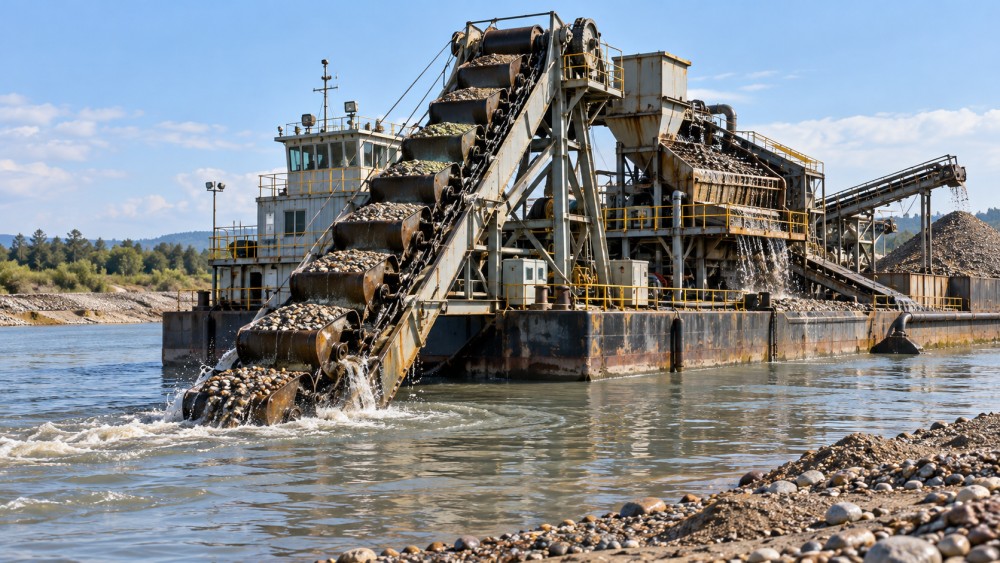
Request an operating-envelope drawing that shows both shallow and deep working positions. It should identify the cutting path, waterline, hull clearance, ladder positions, and discharge arrangement. A machine selected only for its deepest reach may be awkward at the shallow edge of the deposit or during initial development.
Water-level changes must be evaluated against fixed ground elevations. Lower water can reduce the vertical distance from the surface to the deposit, while also restricting flotation or access. Higher water increases the required underwater reach to the same mining floor. The project therefore needs both excavation-depth checks and navigable-water-depth checks; one cannot substitute for the other.
Check whether the buckets can excavate the material at depth
Geometric reach is a necessary condition, not proof of digging performance. Dredger selection also depends on material characteristics, including particle size, cohesion, and obstructions. USACE guidance treats sediment characterization and equipment suitability as linked parts of dredging planning.[2] For an alluvial mining assessment, this means describing the material the buckets will actually encounter, not merely labelling it “sand and gravel.”
The point is to expose constraints that a depth figure cannot describe. A ladder may reach the required elevation while the proposed buckets, drive, or material-handling route remain unsuitable for the encountered layer. Where material behaviour is uncertain, request representative testing or clearly identify the assumption as an unresolved procurement risk.
Bedrock contact deserves particular attention. The specification should distinguish recovery of gravel lying on an irregular surface from excavation of the underlying rock itself. Do not assume that a bucket system proposed for alluvium can cut competent rock merely because its ladder reaches that elevation.
Match excavation output to diamond recovery capacity
Bucket displacement is not recovered production. A preliminary volumetric estimate may start with bucket volume and discharge frequency, but actual feed depends on filling, material behaviour, operating interruptions, and the proportion of useful material excavated. Any conversion from bank volume to loose volume or mass must state its basis. Dredging production estimates and their dependence on operating conditions are discussed in references [1] and [2].
The recovery plant introduces another limit. Screening, scrubbing, concentration, and final recovery must be selected around representative feed characteristics and the intended separation duty. General mineral-processing principles—including liberation, classification, and gravity or dense-medium separation—are explained in Wills’ Mineral Processing Technology.[3] That reference supports the process framework, not a recovery guarantee for an untested deposit.
Technical review should trace material from the bucket discharge through every transfer and separation stage. Identify where oversize leaves the circuit, where clay is treated, which size fractions proceed to recovery, and how rejected material is managed. A high excavation rate has little value if it repeatedly overwhelms a screen or requires the dredger to stop while accumulated material clears.
Depth selection also changes the waste-handling question. If the productive gravel is thin beneath substantial overburden, the project must decide whether stripping and mining will use the same equipment and material route. Passing all excavated material through the recovery circuit should not be the default assumption. Compare operating sequences using deposit-specific volumes, handling requirements, and processing tests.
Separate mining requirements from waterway objectives
Mining and waterway projects can involve similar excavation equipment, but their acceptance criteria differ. A mining operation is concerned with access to the target horizon, dilution, material accounting, and recovery. A navigation project is concerned with the specified channel geometry and the management of dredged material. USACE guidance addresses dredging and material-management planning for civil works applications.[2]
Where a project combines mineral extraction with channel improvement, prepare separate requirements for each objective. A surveyed channel floor does not demonstrate that mineral recovery targets were met. Equally, successful processing does not demonstrate that the required channel profile was achieved.
Environmental and operating permissions should be checked for the actual jurisdiction and site. The review should establish which authorizations govern extraction, dredging, water use, discharge, and placement of rejected material. No general equipment description can establish compliance. Reference [2] provides a planning framework in its US civil works context; it should not be treated as a universal permitting rule.
Turn the depth requirement into verifiable procurement conditions
A useful request for quotation gives suppliers a common design basis. Include the geological sections, water-level envelope, proposed mining floor, material characterization, and required processing duty. Require each offer to identify departures from that basis rather than burying them in general qualifications.
The technical schedule should request:
- Maximum and minimum working depths, with the datum and operating conditions defined.
- Ladder and bucket-path drawings covering the intended excavation envelope.
- Capacity calculations showing material assumptions and downstream constraints.
- Drive, chain, bucket, and structural design information appropriate to the proposed duty.
- Maintenance access, replacement procedures, and proposed critical spares.
- Defined inspection, commissioning, and site-performance acceptance procedures.
Separate dimensional verification from production verification. A survey or witnessed positioning check can establish reach under stated conditions. It cannot establish sustained excavation output in material that was absent during the test. Likewise, a workshop running test cannot demonstrate diamond recovery from the project deposit.
Safety acceptance should be based on a project-specific risk assessment and the applicable machinery, electrical, marine, and workplace requirements. Require documented review of access, guarding, emergency stopping, isolation, and maintenance activities, without assuming that a generic certificate covers the assembled dredging system or its site installation.
The strongest selection is the smallest practical configuration that can work the justified mining envelope, handle the expected material, and supply the recovery circuit under defined operating conditions. Additional depth should answer a documented geological or operational need. It should not compensate for missing investigation, unclear reference levels, or an untested processing assumption.
References
- Bray, R. N., Bates, A. D., and Land, J. M. Dredging: A Handbook for Engineers. Second edition. Arnold, 1997.
- U.S. Army Corps of Engineers. Dredging and Dredged Material Management. Engineer Manual EM 1110-2-5025, 2015.
- Wills, B. A., and Finch, J. A. Wills’ Mineral Processing Technology: An Introduction to the Practical Aspects of Ore Treatment and Mineral Recovery. Eighth edition. Butterworth-Heinemann, 2016.
Related News
 Oct 22, 2026Tunnel Boring Machines in Southeast Asia: EPB vs. Slurry for Soft GroundCompare tunnel boring machines Southeast Asia projects rely on: EPB vs. slurry for soft ground. Discover how groundwater, settlement risks, and spoil handling shape the right choice.
 Oct 21, 2026Choosing Tunneling Equipment for the Middle East: Rock, Soil, and GroundwaterCompare underground tunneling equipment Middle East projects need. Explore rock, soil, groundwater, and TBM options to reduce risk and make confident procurement decisions.
 Oct 20, 2026Which Heavy Machinery Maintenance Standards Apply to Your Construction Fleet?Discover which heavy machinery maintenance standards apply to your fleet. Clarify legal duties, OEM requirements, and inspection rules to reduce risk and keep equipment ready for work.
 Oct 19, 2026Sizing Industrial Hydraulic Power Packs: Pressure, Flow, and Duty CycleSize industrial hydraulic power packs with confidence. Learn how pressure, flow, and duty cycle affect performance, energy costs, and heat control—and avoid costly sizing mistakes.
Related News

Ms. Elena Rodriguez
Weekly Insights
Stay ahead with our curated technology reports delivered every Monday.